

I have had for some time now an app called Flight Radar 24 which some readers may be familiar with. This isn’t a plug for it, but a little perusal of this app will doubtless surprise you. It did me. In the screen shot above you will see in real time the exact position of every plane (the little yellow things) in the air at the time of the screen grab – in this case North America. And the app covers the whole world. The app collects the flight data every civil aviation plane has to broadcast once it is airborne and even on the ground. If you get up close you can see each plane’s movement and with the correct settings, its flight path as well. Plus all available information about the carrier, the plane type, speed etc. It’s mind boggling to think of this many planes in the air at any given time. 5000-10,000 is one figure mooted and that doesn’t include military flights. And that is at any moment in any day, depending on whether the USA is awake or not. Over Africa there appear to be almost no planes at all which speaks volumes. A simple graphic of the disparity between the excessively rich nations and the excessively poor. Read on, it gets worse.

Yes it’s a beautiful picture but don’t be deceived. I don’t want to be alarmist (or maybe I do) but it’s not really beautiful at all.
Fact.
During take-off, a jumbo jet can devour 2 million litres (528,344 gallons) of air per second. In the first five minutes of flight, a commercial airliner can burn as much oxygen as 49,000 acres of forest produce in a day. According to Department of Transportation figures, flying a Boeing 747-400 from Washington, DC to San Francisco burns 17,232 gallons of jet fuel. (Fuel efficiency: 6.7 mpg.) A Boeing 747 averages 32 minutes taxiing, taking off and landing. During this time, it can generate 190 pounds of NOx – equal to the amount produced by driving a car 53,500 miles.
Research by NASA proved that in the North American corridor there are major climatic changes taking place, more than anywhere else. One of the world’s most troubled routes, the North Atlantic Flight Corridor (NAFC) lies between 45 and 65 degrees north latitude and runs almost entirely over water. In 1990, between 700 and 800 aircraft traveled this route between the US and Europe each day – amounting to more than 200,000 flights per year. 27 years later, do you think this has declined?
I haven’t had time to sit in front of FlightRadar24 and count them.
Aside from the air pollution aspect of this which is serious considering that even a recently engineered plane spreads a blanket of toxic gases miles wide, the sheer size of what is going on reflects the huge corporate and commercial activity going on at a global scale and which dwarfs the petty political squabbles taking place in the world which we get hypnotized by. So you get an idea of who is really running the show for their own advantage basically. For example, no mention recently of the $15 billion airplane contract with Iran being cancelled by Trump who pre-election vowed to tear up the nuclear agreement with Iran. They know too darn well that if they did, the order would go directly to Europe or even China. The White House is often called the east coast office of Monsanto for good reason. The Americans, having elected their lower self to the Presidency now have a rather unpredictable and potentially dangerous person running the show and they are having to live with it. Much of this information here is probably known to you all, and is all available on-line but I thought the app mentioned above might give you a tangible perception of what I have been discussing and why it’s worth a quick look. The global media drama serves to distract you from what is really going on.
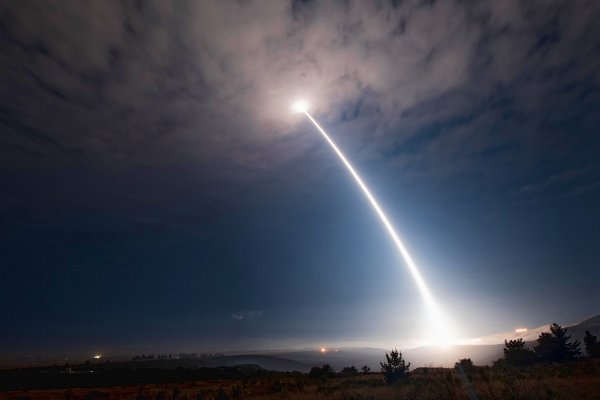
So much is hidden from us and maybe just as well as I think the big picture might just be too much to take. About ten years ago I was traveling over the Oakland bridge in the Bay Area of San Francisco with friends just before sunset and suddenly we saw the enormous awesome plume of a space rocket moving silently and slowly into the upper atmosphere emitting a strange light. Up and up and up it went till with a big blast it vanished. I found out later it was a Star Wars test over the pacific from Vandenburg Airforce Base (the picture above is of a recent test by the US military of an unarmed nuclear missile from Vandenburg). What we witnessed was a $100m firework display by the American military – all over in a few seconds. On the west coast of America you get some idea of the vast and secretive world of the American military industrial complex that is given all it wants from the Federal purse, – whenever it is wanted. It is said that when the US is at war there is full employment on the West coast. In computer software and weapons research, the Federally funded Lawrence Livermore labs just inland from the Bay Area, is where even now research is being made into neutron bomb warfare amongst much else of strategic interest to the US.
Don’t lose sleep over it as you can’t do much about it.
